From Computer Graphics World
15-Oct-2013 Douglas Hope Smith – Sponsored Content
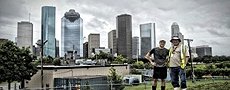
Houston, TX — There are countless inaccessible places in the real world that can be brought into the digital world through 3D data capture. SmartGeoMetrics specializes in helping clients achieve this goal with top of the line hardware, robust and cutting edge software, and experienced personnel.
In 1927, the City of Houston built its first underground drinking-water reservoir at the Water Works on Sabine Street. Decades later it started to leak. The leak could not be found, let alone patched. The reservoir was drained and remained out-of-sight and largely forgotten.

Cistern interior, Google Earth Image of the Cistern site and surroundings, Point Cloud consisting of 51 individual scans of the Cistern and surrounding Water Works, 2D Site Plan Drawing extracted from the Registered Point Cloud, 3D Model of the Cistern rendered from the Point Cloud
In 2011 the Buffalo Bayou Partnership (BBP) took possession of the Water Works as part of Buffalo Bayou Park Development. In the course of due diligence of the property, they entered the reservoir through a small hatch and descended a single ladder into its cavernous space. What they encountered was beyond their expectations.
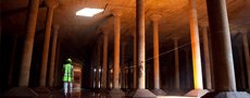
Light fell into the space from the entry hatch as well as two larger equipment hatches. It reflected off of six inches of water that covered the floor of the space shimmering on the walls and illuminating row after row of towering columns. Each step echoed and voices were amplified, claps of the hands reverberated for what seemed like eternity in this room large enough to hold one and a half football fields. The reservoir was dubbed, “The Cistern.”

Images of varying exposures inside the Cistern, 300 lbs of equipment was lowered through a narrow hatch down into the Cistern, Laser scanning technologies will even work in complete darkness.
A space like this begged to be shared. However, the logistics required to enter the Cistern are extensive and complicated: security clearances, confined spaces certification, an evacuation winch, a safety lanyard, gas monitor, hole watch, liability releases, scheduling access… How could people safely experience it?
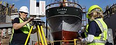
SmartGeoMetrics (SGM) heard of the “Cistern” through a bit of water cooler talk as their offices are neighboring those of the Buffalo Bayou Partnership (BBP). SGM’s solution was to digitize the entire space as well as the surrounding features above ground. This would allow the BBP to share and promote their newly discovered assets through a myriad of digital mediums.
300 lbs of equipment was lowered through a narrow hatch down into the Cistern, High Definition Laser Targets used to Register (stitch) individual scans into one unified scan.
While making digital models of real world places has been possible for some time now, it was akin to retyping a hand written letter. The content was successfully recreated but something was often lost in the digital translation. That all changed when scanners were invented. Users could quickly scan a document and either view the original or convert it into an editable format. This same transformation is now occurring but with real world environments instead of sheets of paper. The equivalent of a JPG of a document, or the raw data format for 3D Imaging is the “Point Cloud”. Like the JPG in 2D scanning these point clouds can be viewed and give users an accurate representation of the captured environment. Point clouds can also be used to create editable formats like CAD models, meshes, or NURBS models.
Equirectangular projection of a raw laser scan data captured with a Leica HDS 6200 scanner, Registered Point Cloud consisting of 51 individual scans, Screen shoot of an individual scan with X,Y and Z values; notice the foot prints, The Cistern and Water Works Registered Point Cloud consisting of 51 individual scans, 3D Rendering from scan data, 2D Site Plan Drawing extracted from the Registered Point Cloud.
Registered Point Cloud consisting of 51 individual scans
The key advancements are not just the speed increases or incredible improvements in accuracy over traditional “artistic” modeling but the concept of having a single data source from which multiple computer applications can data mine. From one data collection campaign you have a perfect copy of the environment that is at the mercy of whatever applications you have! Create architectural drawings, use it as the environment for a video game or movie, make fly-through videos, print 3D models, build Building Information Models (BIM) for asset management, make VFX models, and more. Nothing exists in a vacuum, why model in one when you can design, study, manage, or create objects in the environment in which they will exist.